A promising parody died today in an accidental lapse of diction by its author. The fable "The Devil Made Me Write This" by an unnamed satirist best known for his frequent Facebook jabs at Donald Trump, succumbed to the effects of mistaking fair for fare and later child baring for childbearing.
In a necropsy of the experience, the writer's former diction and spelling coach Esmeralda Effingham of Pennsylvania observed, "we always knew he'd come to a bad and," which comment lent perspective on the recent faux pas.
Other commentators observed that either mistake alone might have been overlooked but that the presence of ambiguity in both the introduction to the piece and the socko finish were in the aggregate too much to bear. (The Big Bear Aggregate Co. of Hardrock, AZ, had no comment but said it had referred the matter to counsel.)
Film at 11.
Ed. note: Child baring is an offense in 17 states.
ReesClark.com
Momentum
☰
Geography
Fable Dies Tragically in Spelling Accident
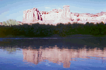
Reflected glory
I've always been happy to have been a graduate student at Penn State University's geography department in 1969-72. Being somewhat slow by comparison with some of my fellow students I was lucky to have been tutored by some of geography's finest. It's easy for me to identify the skills both personal and professional that I gained there. All told, one of my best way stops. My doctoral committee was headed by Ron Abler, who overcame that possible embarrassment by continuous progress through a distinguished career. The following is his biography, found at the International Geographical Union, which only scratches the surface.
"Ronald F. Abler has been active in the International Geographical Union (IGU) since 1976. He was a charter member of the IGU Study Group and the IGU Commission on the Geography of Communications and Telecommunications from 1984 to 1992. Following his 1996-2000 term as Vice President, he was elected IGU Secretary General and Treasurer in 2000 and served in that capacity through 2006, when he again became an IGU Vice President.
"Ronald F. Abler has been active in the International Geographical Union (IGU) since 1976. He was a charter member of the IGU Study Group and the IGU Commission on the Geography of Communications and Telecommunications from 1984 to 1992. Following his 1996-2000 term as Vice President, he was elected IGU Secretary General and Treasurer in 2000 and served in that capacity through 2006, when he again became an IGU Vice President.
If I could choose any ten days...
Sep 27, 1999 -- When I was in the second grade in 1949-50, my two best friends at Longden School were Suzanne Holmes and Annette Blanchard. At the end of the day, I hated to get on the school bus to go home.
Suzanne and Annette and I have gone down mostly separate roads over the past few decades, but it's been my great joy to renew our friendship since a class reunion in 1990.
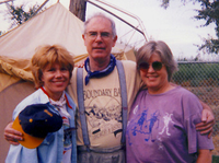
In August of 1998 they invited me to go canoing on the Green River in Utah, near Annette's home. Suzanne came from Southern California, and I came from Seattle. We camped out along the river for nine days, along with Rocky Mountain friends, Dion Corkins, Alene Watson and Sandy Dickinson. Pictured at right are Suzanne, Rees and Annette on the rainy first morning of the ten day excursion. Strangely, I'm the only one with white hair.
After nine days of paddling (see pix below), we were happy to let the jet boat carry us back up the Colorado to Moab. Guess what! Again a school bus.
It turns out that I was never so smart again as I was in the second grade. All things considered, I'd rather be in the canoe. Although I'm fairly sure I was invited for my ability to fling large bundles onto the bank from the canoes, I don't mind; the company made it all worthwhile -- no, wonderful. At the end of the trip, I hated to get on the school bus to go home. Plus ça change...
Here are some photos by Suzanne.
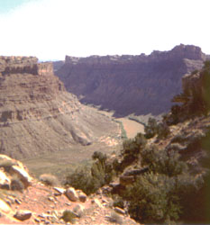
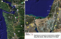
The Green River (shown here cleverly disguised as the brown river) descends through thousands of feet of sediments to its confluence with the Colorado. Our trip was about 120 miles.
We camped out each night. Two days of rain were followed by seven of sunshine.
Rees the amateur was lucky to have an experienced paddler like Dion Corkins to keep him pointed in the right direction.
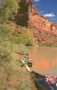
The well-appointed resort-like facilities along the waterway. There were other guests: One morning I discovered within our camp the paw prints of a cat that had been drinking from a small tributary overnight. They were four inches across.
The shade was often the most beautiful part of the trip in the middle of the days. We asked Suzanne to photograph some spectacular scenery, but there wasn't any. (That's the understated humor; an understanding smile would be good right now.)
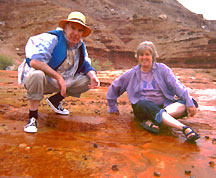
An experimental oil well drilled decades ago produced little oil, but it provided a source of mineral water that encrusts the surrounding rocks with orange, red, yellow and brown precipitates that support a variety of tiny organisms. (Here are two of the tiny organisms inspecting the others.)
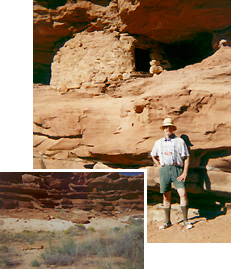
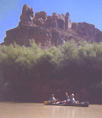
A highlight of the trip was the opportunity to visit several cliff dwellings (approx. 1,000 years old).
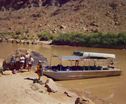
The jetboat awaits alongside the Colorado. Hard to see in this pic, but the water one one side appears green by contrast and on the other it's red; thence the names Green and Colorado (red) rivers, one supposes.
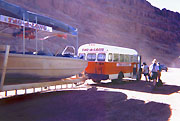
The school bus; a metaphor for life. It comes too soon, and just in time.
The moral of the story is that if Annette Blanchard Rose ever shows you a picture she drew of a flower pot, say something nice. It may take 50 years, but there's a huge reward. (I could explain, but it's a whole other story.)
Travels to date
Here's a map I got by clicking the names of states and countries visited. Visit the URL below to make your own. Then copy the text they give you to post your map to your site.
US

visited 48 states (96%)
Create your own visited map of The United States or try another Douwe Osinga project
World

visited 16 states (7.11%)
Create your own visited map of The World or try another Douwe Osinga project
US
visited 48 states (96%)
Create your own visited map of The United States or try another Douwe Osinga project
World
visited 16 states (7.11%)
Create your own visited map of The World or try another Douwe Osinga project
Pick a better fight
The Internet @ 15
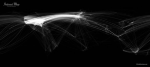
Since the popularization of the Internet in 1993 usage has spread worldwide, but a few areas still predominate. As the 'net approaches its 15th birthday, someone sent me this trace map of traffic.
Major Geog
This category is dedicated to the valiant Major Geog, whose exploits in the mystical Wumpus caves of Colgate University in the 1970s brightened many hours during my dissertation labors. Major Geog slew many a wumpus, but sadly met his end in 1978 when his biggest booster took his younger brother and moved to California. Dejected, Major Geog wandered into the caves and was never seen again.
Library of Congress Maps

The Geography and Map Division of the Library of Congress holds more than 4.5 million items, of which Map Collections represents only a small fraction, those that have been converted to digital form.
The focus of Map Collections is Americana and Cartographic Treasures of the Library of Congress. These images were created from maps and atlases and, in general, are restricted to items that are not covered by copyright protection.
Map Collections is organized according to seven major categories. Because a map will be assigned to only one category, unless it is part of more than one core collection, searching Map Collections at this level will provide the most complete results since the indexes for all categories are searched simultaneously.
Recent Posts